
The Geography of Vietnam: Rivers, Cities and Economic Growth
What actually makes a geography-focused school trip meaningful, rather than just another destination on the itinerary? For many school leaders and trip organisers, the challenge is finding places where students can clearly see how physical landscapes shape real economies, communities, and ways of life.
Vietnam stands out because the connection between geography and development is immediate and visible. River systems support entire agricultural regions, coastal and lowland areas influence trade and settlement, and rapidly expanding cities reflect deeper economic change. These are not abstract concepts. They are patterns students can observe, question, and understand in context.
In this article, we explore how Vietnam’s physical geography influences its economy and culture, from the role of the Mekong Delta to the impact of urbanization. We also look at how these insights can be translated into structured, high-impact learning experiences through well-planned educational travel.
Key points covered in this article:
How Vietnam’s physical geography shapes its economy and daily life
The role of the Mekong Delta in agriculture and food production
Why rapid urban growth in cities like Ho Chi Minh City and Hanoi matters
What students can observe and learn through educational travel in Vietnam
The Mekong Delta and Agriculture
If you are trying to show students how geography directly influences livelihoods, the Mekong Delta is usually where everything clicks.
It is not something you need to over-explain. Once you are there, the relationship between land, water, and daily life becomes obvious very quickly. Fields stretch out in every direction, but they are broken up by canals rather than roads. Boats are not a novelty. They are part of everyday movement, whether that is transporting rice, produce, or people.
For trip planning, this creates a clear opportunity, but also a decision. Do you want students to observe agriculture at scale, or understand how it works at a community level?

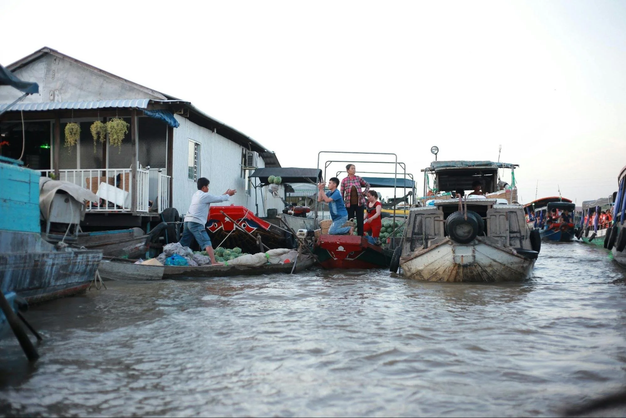
Students exploring how waterways shape daily life and agriculture in the Mekong Delta.
Seeing Agriculture as a System, Not a Snapshot
The Mekong Delta produces a large proportion of Vietnam’s rice, along with fruit, vegetables, and seafood. It is easy to visit a farm or pass through rural areas and point this out, but that alone does not give students much depth.
For example, the delta’s flat land and constant water supply make it ideal for rice farming. At the same time, that same reliance on water creates vulnerability. Seasonal flooding, changing river levels, and upstream developments all affect how and when crops can be grown.

Understanding agriculture as a system influenced by geography and water access.
What Students Can Actually Observe on the Ground
One of the advantages of the Mekong Delta is that students do not need technical knowledge to start making connections.
Students on educational trips to Vietnam might notice how:
Farms are closely linked to waterways rather than road networks
Boats are used to move goods in places where trucks would be inefficient
Homes are positioned or built in ways that reflect changing water levels
These are small details, but they open up bigger questions. Why is this system efficient here, but not in other countries? What happens if water levels become less predictable? How would farmers adapt?
Choosing the Right Type of Experience
Some itineraries focus on short visits to floating markets or general sightseeing. These can be engaging, but they often stay at the surface level. Students see activity, but do not always understand the underlying system.
Other approaches go a step further. Spending time in a rural community, speaking with local producers, or observing how farms operate across different times of day can give a much clearer picture of how geography shapes decision-making.
The trade-off is usually time. Deeper experiences require slower pacing and fewer locations. Trying to fit too much into one day often reduces the learning to quick impressions.
Connecting It Back to the Curriculum
The Mekong Delta works particularly well because it links directly to topics many students are already studying. Agriculture, resource management, climate impact, and economic development are all visible in one place.
Before the visit, it helps to set a focus. For example, students might be asked to compare agricultural methods with those in their home country, or to identify risks and advantages within the local system.
After the visit, reflection becomes just as important. Without that step, even strong experiences can remain disconnected from classroom learning.
Vietnam’s Rapid Urban Development
If your itinerary only focuses on rural Vietnam, students will leave with an incomplete picture.
Cities like Ho Chi Minh City and Hanoi tell a very different story. They show what happens when geography, population growth, and economic ambition all meet at speed. For trip organisers, this is often where the most immediate, visible contrasts appear, sometimes within a single day.

Experiencing the pace and complexity of rapid urban development in Vietnam.
You can move from a quieter district into an area filled with construction, dense traffic, and new commercial spaces in a matter of minutes. That shift is not random. It reflects how Vietnam is evolving, and it gives students a way to understand urbanization as something active, not theoretical.
What Urban Growth Actually Looks Like on the Ground
Urban development in Vietnam is not uniform. It does not follow a neat pattern where old is replaced by new, instead it layers.
You might see modern office buildings next to older housing, street markets operating beside large shopping centers, or small family-run businesses continuing in areas surrounded by new infrastructure. For students, this can be confusing at first, but that is exactly where the learning sits.
Rather than explaining it upfront, it often works better to let them notice the contrasts and then ask what might be driving them. Why has one area developed faster than another? Who benefits from these changes, and who might be left out?
Planning Around Trade-Offs, Not Just Highlights
There is a tendency to treat cities as logistical hubs rather than learning environments. They are where students stay, eat, and move through, rather than places to study in their own right.
Urban Vietnam allows students to explore real trade-offs. Economic growth brings investment, jobs, and infrastructure, but it also creates pressure on housing, transport, and public space. These are not abstract issues. Students can see them in traffic congestion, construction patterns, and the way public areas are used.
From a planning perspective, this raises an important decision. Do you prioritize convenience and keep city time structured and limited, or do you intentionally build in time for exploration and observation?
In our experience, even a short, well-framed activity in a city can add more value than simply passing through it.
Turning a City Visit Into Something Meaningful
A useful approach is to give students a specific lens before they go out into the city.
For example, you might ask them to focus on how space is used. In some areas, every available space is active, whether for transport, business, or housing. In others, you may see more formal planning, wider roads, or newer developments.
Another option is to look at movement. How do people get around? What does that tell you about infrastructure and access? Why are certain forms of transport more dominant in some areas than others?
Balancing Pace and Depth
One of the practical challenges with urban environments is time pressure. Cities are often where schedules tighten, especially when combined with travel days, internal transfers, or accommodation logistics.
It can be tempting to compress everything into short windows, but that usually limits what students take away. Rushed exposure rarely leads to meaningful understanding.
Slowing things down slightly, even by adjusting one part of the itinerary, can make a noticeable difference. Giving students time to walk, observe, and reflect often leads to more valuable discussions than trying to cover multiple locations quickly.
Experiencing Vietnam’s Geography Through Educational Travel
A well-planned itinerary in Vietnam can either feel like a series of interesting stops, or it can function as a connected learning experience where each location builds on the last. The difference usually comes down to how intentionally geography is used as the thread throughout the trip.

Comparing different regions to understand how geography shapes development.
One approach we often recommend is to think less about “places to visit” and more about “questions to explore.” For example, instead of simply including the Mekong Delta, Hanoi, and a rural northern area as separate highlights, you might frame the trip around a central idea such as: how does geography influence economic decision-making across different regions?
Building a Coherent Learning Journey
A common mistake is trying to cover too much ground without giving students time to connect what they are seeing. Vietnam offers a lot of variety, but that does not mean every trip needs to include every type of landscape.
A more effective structure might look like this:
| Focus Area | Location Example | What Students Can Explore | Key Trade-Off |
|---|---|---|---|
| River-based economy | Mekong Delta | Agriculture, water systems, livelihoods | Travel time to reach rural areas |
| Urban growth | Ho Chi Minh City | Infrastructure, economic development, inequality | Risk of treating it as transit rather than learning time |
| Regional contrast | Northern Vietnam | Terrain, settlement patterns, cultural diversity | More complex logistics |
Deciding Between Breadth and Depth
This is usually one of the first real decisions a trip organiser needs to make.
If you aim for breadth, students experience multiple regions. They see contrast, which can be powerful, but the pace is tighter and reflection time is limited.
If you prioritize depth, students spend longer in fewer locations. They gain a clearer understanding of how a specific system works, but may miss the wider national picture.
Turning Observations Into Learning
Being in Vietnam is not enough on its own. Students need a simple structure to help them interpret what they are seeing.
In practice, this does not need to be complicated. It could be as straightforward as asking students to track one theme throughout the trip, such as how geography influences transport, housing, or economic activity.
For example:
In the Mekong Delta, they might look at how water shapes farming and trade
In cities, they could examine how space is used and how infrastructure adapts to growth
In northern regions, they might focus on how terrain affects settlement and agriculture
Making It Work Logistically
Travel distances in Vietnam can be longer than expected, especially when moving between regions. Internal flights save time but reduce opportunities to observe transitions between landscapes. Road travel offers more visibility but requires careful pacing to avoid fatigue.
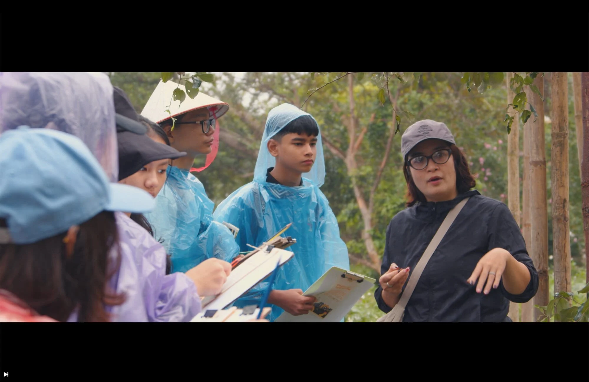
Students interpreting real-world environments through structured observation.
Accommodation choices also play a role. Staying closer to the environments you want students to study, whether that is a rural area or a city district, can make a noticeable difference in how much they engage with their surroundings.
Planning With Geography in Mind, Not Around It
When we speak with schools early in the planning process, a common pattern comes up. Destinations are often chosen first, then learning objectives are added afterward. This usually leads to a busy itinerary that feels full, but not always connected.
Reversing that approach changes the outcome. Start with a clear question or focus, such as how geography influences economic activity or how environments shape daily life. From there, each location begins to serve a purpose. The Mekong Delta is no longer just a rural stop. It becomes a way to understand agricultural systems. Cities are not just transit points. They become case studies in urbanization and development.
This shift also makes decision-making easier. It helps you prioritise where to spend time, where to simplify, and where to go deeper. More importantly, it gives students a clearer framework for understanding what they are seeing while they are there.
What Actually Makes the Difference on the Ground
Define a clear geographic focus before confirming locations
Choose fewer regions and allow time for deeper exploration
Build simple observation tasks that help students interpret what they see
Align travel timing with both logistics and learning opportunities, including climate conditions
Treat cities as learning environments, not just accommodation bases
We work with schools to design itineraries that connect geography, economy, and culture in a way that students can engage with directly. That includes shaping the learning focus, selecting the right locations, and building in the time and context needed for meaningful exploration.
If you are reviewing options or refining an existing plan, exploring how a structured approach can improve outcomes is a useful place to start. You can learn more about how we design and deliver these experiences through our Vietnam programs.